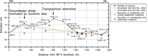
Fig.2-16 Schematic view of the surface hydrological investigation
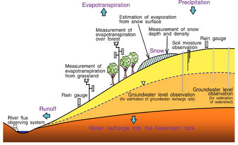
Fig.2-17 Comparison between topographical watershed and groundwater divide
After rain and snow fall, there is evapotranspiration from plants and the ground surface, and runoff into rivers and lakes. The rest seeps underground through the soil. Knowing this recharge rate is necessary for groundwater flow analysis which in turn is important to evaluate the safety of geological disposal. Recharge rate is estimated by considering the above water balance of precipitation, runoff and evapotranspiration because it is difficult to measure directly.
In the Horonobe Underground Research Laboratory Project, we carry out surface hydrological investigations which consist of meteorological observation, observation of river flux and water quality, soil moisture observation and groundwater level observation in shallow boreholes extending several meters below the ground surface. These investigations aim to aid in developing the methodology to understand water balance and groundwater flow properties, by application of the series of research techniques used for these observations specifically to the estimation of recharge rate (Fig.2-16) .
From the current investigation, recharge rate of this whole area can be estimated as about 120 mm a year, which corresponds to 10% of precipitation (about 1,375mm a year) in this area. We also confirmed that the topographical watershed differs from the groundwater divide found in shallow borehole data. These results provide significant information for setting the boundary and initial conditions for groundwater flow analysis (Fig.2-17) .
We plan to evaluate the validity of these methodologies and the results of these investigations, including the appropriateness of the size of the observation areas, by comparison of observations up to now with data of the distribution of water quality and age, etc. and precise observations of precipitation and evapotranspiration taking account of snow accumulation.