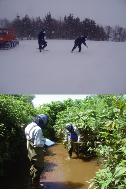
Fig.2-24 Implementation of the surface hydrological survey
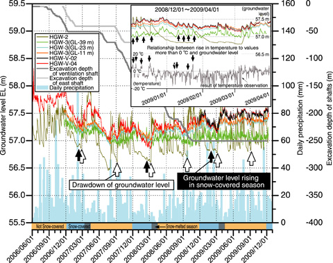
Fig.2-25 Results of groundwater-level observation around the Horonobe URL
To assess the safety of geological disposal of high-level radioactive waste, it is important to understand groundwater flow as a driving force of mass transport. To estimate groundwater flow by performing a numerical simulation, the upper hydraulic boundary condition of an aquifer must be appropriately evaluated and configured on the basis of the water supply. Therefore, shallow groundwater flow system, including water infiltration from the surface to shallow underground, subsurface runoff, and deep groundwater recharge, should be considered on the basis of hydrological information.
We have been carrying out the following surface hydrological observations in Horonobe, Hokkaido: meteorological observation, observation of river flux, observation of shallow groundwater level, and snowfall observation (Fig.2-24). In this study, to elucidate the mechanism of the water supply from the surface to the shallow underground region during cold snowy conditions, we estimated and analyzed the results of meteorological and long-term groundwater-level observations by using approximately 3∼50 m deep boreholes, by considering the geological structures in the surrounding area. The results indicate that during snow season, the snow melting from the bottom of a snow cover supplies the shallow underground region with water and that the groundwater level rises due to the melting of the snow on the surface as the temperature rises above 0 °C (Fig.2-25). In addition, from the results of long-term observations, it has been clarified that the shaft excavation for the construction of the Horonobe underground research laboratory (URL) does not cause a drop in the shallow groundwater level.
Previously, it was very difficult to estimate accurately the water balance throughout the year for snowy cold regions, because obtaining hydrological and meteorological data and carrying out geological survey in snow season is difficult. This study supplies qualitative information about water infiltration from the surface to underground region in cold snowy areas and implements the evaluation of the hydrogeological environment throughout the year.
<Previous: 2-9 | Next: 3 Nuclear Fusion Research and Development >

