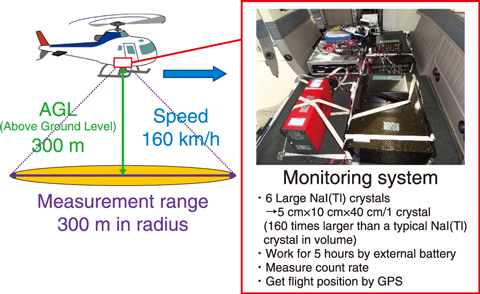
Fig.2-16 Overview of ARM
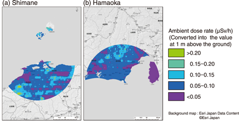
Fig.2-17 Example results of ARM
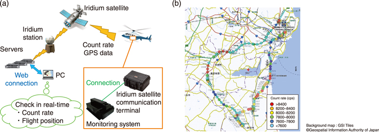
Fig.2-18 Real-time ARM Data Communication System
During a nuclear emergency, aerial radiation monitoring (ARM) via aircrafts such as manned helicopters could be utilized to aid decision-making in public protective actions and to evaluate the residual environmental radiological effect. ARM allows for rapid and widespread measurements (Fig.2-16), including in remote or relatively inaccessible regions, such as forests, mountains, or areas with a relatively high dose rate. In fact, ARM had been performed to map the ground deposition of radioactive nuclides in the months immediately following the accident at TEPCO’s Fukushima Daiichi Nuclear Power Station. In the more than nine years since this incident, ARM has been further developed and is now fully prepared to use following in the event of a nuclear emergency.
Firstly, all considerations to ensure safe deployment of ARM have been performed, as has the measuring of the natural background radiation level surrounding the nuclear power stations in Japan. In 2018, ARM was conducted to acquire these data within an 80-km radius surrounding the Shimane and Hamaoka Nuclear Power Stations; the resulting maps of the natural background dose rate are shown in Fig.2-17. Since much of the area surrounding the Shimane Nuclear Power Station is within the controlled airspace of airports and government agencies, it is necessary to get flight permission from air traffic authorities beforehand. In the Hamaoka area, it is vital to have a detailed understanding of the location of densely packed aerial cableways to prevent collisions, particularly in precipitous mountain areas. This data collection process and development of background radiation maps will allow for the prompt performance of ARM and evaluation of environmental radiological effects during a nuclear emergency.
Secondly, the Real-time ARM Data Communication System (Fig.2-18(a)) was developed to provide ARM results swiftly during a nuclear emergency. This system allows ARM data to be shared on the ground via satellite, thus enabling real-time monitoring (from a PC) of the helicopter’s location and measured radiation levels. To test the data communication capabilities, a test was run from a car driven in Ibaraki Prefecture; the results, shown in Fig.2-18(b), demonstrated that the count rate and position of the car were correctly displayed without interruption. A similar test via helicopter is now being planned, as is the introduction of a program that automatically calculates the ambient dose rate from ARM data to further aid decision-making in public protective actions during a nuclear emergency.
This study was conducted as part of the contract research in FY2018, sponsored by the Nuclear Regulation Authority (NRA), Japan.
(Akira Futemma)

