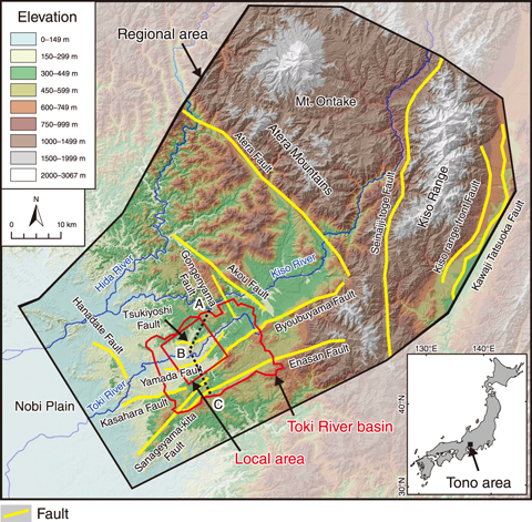
Fig.8-18 Regional setting of the case study
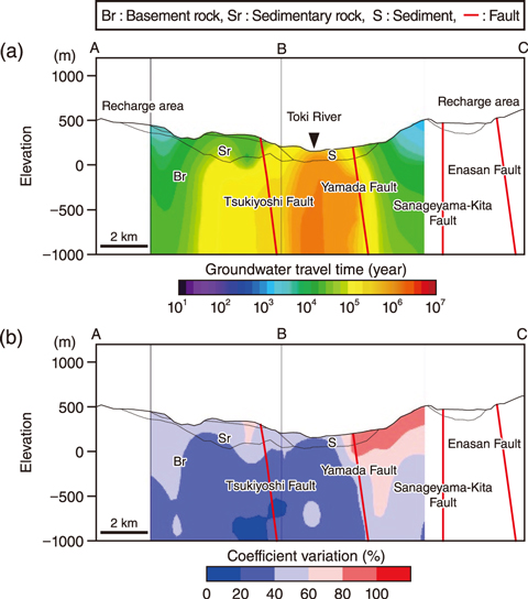
Fig.8-19 Modeled groundwater flow conditions in the deep underground
Safety assessments of the geological disposal of high-level radioactive waste are performed on a time scale of more than tens of thousands of years after the closure of the facility. As part of this assessment, the effects of long-term topographic change and climate perturbations on the geological environmental characteristics must be estimated. Therefore, a quantitative evaluation method of the effects of long-term geological phenomena on groundwater flow conditions, such as the velocity and travel time of groundwater, was developed.
In this method, the coefficient of variation is calculated based on steady-state groundwater flow simulations for quantifying the effects of long-term geological phenomena. The coefficient of variation is the standard deviation of data divided by the average value; a lower value indicates a lesser relative variation with respect to the average value of the data. Further, it is not affected by the influence factors.
First, a steady-state simulation was first conducted using a present-day hydrogeological model of the Tono area (Fig.8-18). As a result, a region with a slow groundwater flow was estimated to be distributed in the deep underground of the Toki River surrounded by the Tsukiyoshi Fault and the Yamada Fault (see Fig.8-19(a)). Second, topographic changes and climate perturbations over the past one million years were estimated, and hydrogeological models of 1 Ma (million years ago), 0.45 Ma, and 0.14 Ma were constructed. Two recharge rate patterns were estimated for each model considering climate perturbations. The coefficient of variation was calculated based on the steady-state simulation results of eight hydrogeological models. The results indicated that the region with slow groundwater flow is distributed in the area where the coefficient of variation is relatively small (see Fig.8-19(b)), thus suggesting that the deep underground area below the Toki River has not been susceptible to topographic change and climate perturbations over the past 1 Ma. It was also estimated that the groundwater flow in the deep underground of the Toki River is slow, based on the groundwater chemistry data. The validity of the results of this study was then confirmed.
This proposed evaluation method, which can quantitatively estimate the effect of topographic changes and climate perturbations on groundwater flow conditions, is an effective technique for assessing geological disposal, as it requires the evaluation of long-term changes in the geological environment characteristics over tens of thousands of years.
This study is part of the results entrusted in FY2016, supported by the Agency for Natural Resources and Energy (ANRE), the Ministry of Economy, Trade and Industry (METI), Japan.
(Hironori Onoe)

