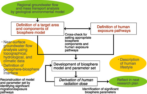
Fig.2-9 Biosphere model in surface and near-surface environments: development overview flow chart
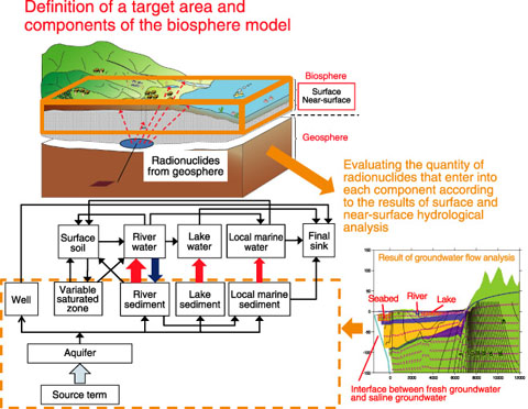
Fig.2-10 Image of biosphere model development using the information acquired at actual surface and near-surface environments
In the safety assessment of a deep geological disposal system for high-level radioactive waste (HLW) and transuranic waste (TRU), there is a need to consider the surface and near-surface environment (biosphere) into which future releases of radionuclides via groundwater might occur and associated future human behavior. This is called “biosphere assessment. ” In biosphere assessment, it is often necessary to estimate future human radiation exposure doses.
The radioactive waste disposal project is currently at the repository site selection stage. We need to develop a methodology for developing site-specific biosphere models and a priority list of the biosphere parameters that should be acquired at the repository site. It is especially important to indicate a practical procedure for developing biosphere models based on information acquired at specific surface and near-surface environments. Fig.2-9 shows a flow chart for developing a biosphere model based on information required at a specific environment. The top left side of this chart shows the practical procedure for evaluating groundwater flow in the near-surface environment in order to define a target area and components of the biosphere model. This is one of the most important procedures, because this result points to the area where radionuclides enter into the biosphere. Fig.2-10 shows the concept for developing a biosphere model based on information acquired at a specific environment.
In parallel to the development of this flow chart, we prepared a list of the data required to develop the biosphere model at each stage of the radioactive waste disposal project. This list shows the data and their sources (references) required to define a target area, biosphere components, and exposure pathways. The chart and the list provide a practical procedure for handling the data acquired at a specific site environment, and this would serve as a guide for biosphere modeling at the site. We should develop a procedure specific to biosphere assessment in Japan, because the data required for biosphere modeling and the importance of that data differ from country to country. Our goal is to put this methodology to practical use as a knowledge base that indicates a systematic approach to biosphere modeling.

