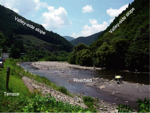
Fig.2-4 Typical topography in the middle-reach of a river
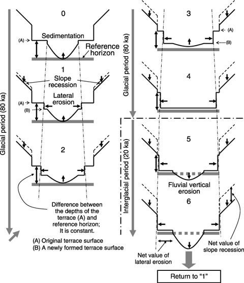
Fig.2-5 Conceptual model of fluvial erosion (one glacial cycle)
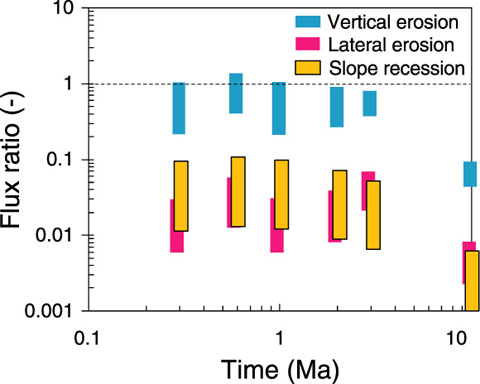
Fig.2-6 Illustration of the calculated impact of repository exposure
In Japan, areas where rapid uplift has been recorded in the past 100 thousand years are disqualified as potential sites for geological disposal of nuclear waste. However, analyses of uplift/erosion scenarios are essential to ensure the robustness of a deep HLW repository system, considering that uplift/erosion would take more than 100 thousand years to expose a repository.
In a previous study, a simple but conservative conceptual model was adopted, in which an entire repository was exposed at once and was eroded uniformly, although Japan has an undulating topography, mainly because of fluvial erosion.
In this study, the topographical changes caused by fluvial erosion were examined and the following were identified: (1) erosion/sedimentation on riverbeds, (2) lateral erosion to form terraces, and (3) recession of the valley-side slope (Fig.2-4).
Besides, it is evident that riverbed deepening depends on glacial cycles. In the middle reach of rivers, there is increased production of detritus during a glacial epoch, which lasts for 80 ka. Sedimentation progresses as the detritus accumulates on the riverbed because of the decrease in the intensity and frequency of floods. As a result, fill-top terraces are formed. In contrast, the production of the detritus decreases and the intensity and frequency of floods increase during the interglacial period, which lasts for 20 ka resulting in riverbed deepening.
On the basis of this phenomenological understanding, a conceptual model of fluvial erosion was created (Fig.2-5).
The mechanism of topographical change is expected to remain the same in the far future, when the repository will be e xposed. Consequently, the bedrock surrounding the repository will be denuded gradually, over a period of more than tens of thousands of years.
The radiological impact of the exposed repository was compared with the natural radiological toxicity (Fig.2-6). The results showed that depending on various conditions, such as repository depth, uplift rate, and topography (ridge-to-ridge distance, terrace height, etc.), the average toxicity of the detritus formed during repository denudation would be lower than or almost equal to that of the uranium deposit in Japan (0.05 wt% U3O8).

