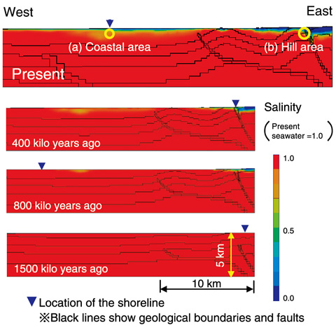
Fig.3-20 Evolution of groundwater salinity
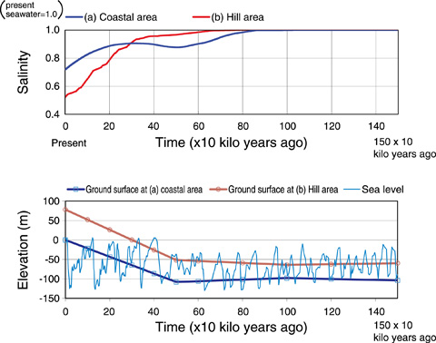
Fig.3-21 Evolution of groundwater salinity at 300 m depth
It is crucial to demonstrate how the geosphere evolves over tens of thousands of years to ensure acceptance of the very long-term safety of geological disposal by society at large. One of the main methods for describing such future evolution is the extrapolation of past evolution based on phenomenological understanding; another method is numerical simulation by considering the mechanism of geosphere evolution. In this study, we reconstructed the evolution of groundwater flow/salinity over the past 1500 ka in Horonobe, northern Hokkaido, using numerical simulation developed at JAEA toward the development of a methodology for describing geosphere evolution over very long time periods in coastal and sedimentary environments.
We developed a methodology involving numerical simulation of the evolution of groundwater flow/salinity by considering geometric changes of topography/geological structures caused by uplift/subsidence as well as changes in groundwater recharge and sea level as a result of climate change. Application of the methodology to the Horonobe area suggests groundwater salinity decreases gradually in uplifted land areas, which were originally on the sea floor at 1500 ka (the uplifted area at the eastern end of Fig.3-20). The results also indicate the wide distribution of groundwater of very low salinity, i.e., fresh water, under the sea floor at present (the coastal area in uppermost Fig.3-20). This fresh water distribution was formed by the infiltration of rainwater when the present sea floor was land. The groundwater salinity at 300 m depth decreases with uplift in both coastal and upland areas, exhibiting different trends depending on the elevation change in each area (Fig.3-21).
The simulation results are confirmed by geophysical and borehole investigations. Furthermore, this study contributes to improving the technical basis for describing evolution of the geosphere over very long time scales in coastal and sedimentary environments.

