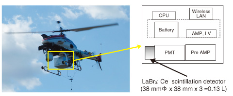
Fig.1-6 Radiation monitoring system using an unmanned helicopter
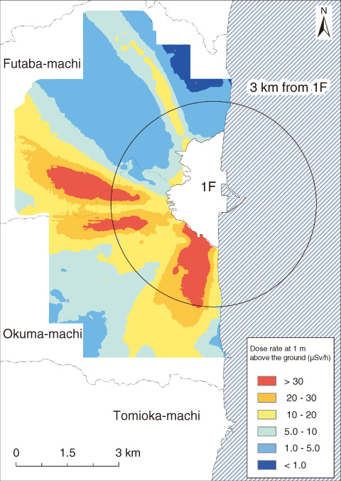
Fig.1-7 Map of dose rate in area surrounding the 1F
After the accident at the TEPCO’s Fukushima Daiichi NPS (1F), a method by which the radiation in a large area can be promptly measured was needed. We clarified the radiation distribution in Japan by aerial radiation monitoring using aircraft (a manned helicopter). However, because Japanese regulations prohibited travel within a 3 km range of the 1F, aerial radiation monitoring using the aircraft was not performed. Thus, we attempted to make a radiation distribution map using a radiation detector installed in an autonomous unmanned helicopter (AUH).
The AUH employed an R-MAX G1 made by Yamaha Motor Co., Ltd. The AUH consists of an unmanned helicopter used for pesticide dispersion with an added capacity for autonomous functioning (Fig.1-6). We developed a radiation monitoring system that was installed in the AUH. We adopted the LaBr3: Ce scintillation detector to obtain the energy spectrum of γ-rays. This system could save not only the positional information obtained by differential GPS (DGPS), but also the radiation data, every 1 s. The data from the scintillator (gross count rates) were converted into the air dose rate at 1 m above the ground using a pre-set parameter. A contour map based on the analyzed dose rate at a 1 m height was made using Geographic Information System (GIS) software. The unmanned helicopter flew about 80 m in altitude above the ground at a speed of 8 m/s. The line spacing of the flight was 80 m for agreement with the flight altitude. The measurement results obtained by the AUH system exhibited a good correlation with those of measurements by a survey meter on the ground.
The contour map of the dose rate around the 1F is shown in Fig.1-7. The high dose rate area extends not only in the southern direction but also in the western direction from the 1F. Moreover, the high dose-rate area in the western direction was divided into two areas. It can also be seen that the high dose-rate area extended in the northwestern direction. The shape of the distribution is attributed to the weather conditions at the time of the accident and the topography.
This map is available to the public on the homepage of the Nuclear Regulation Authority (https://fukushima.jaea.go.jp/initiatives/cat03/pdf04/5-1-2.pdf).
The present study was conducted under a contract with the Ministry of Education, Culture, Sports, Science and Technology of Japan (MEXT) in fiscal year 2013.

