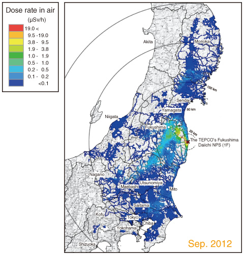
Fig.1-5 Example of large-scale car-borne survey data using KURAMA
In order to properly estimate the effects of radionuclides released by the accident at the TEPCO’s Fukushima Daiichi NPS (1F) on the environment and human health for a long period and take appropriate countermeasures, it has been necessary to obtain detailed information on the air dose rates over wide areas. We established a system that can obtain a large amount of air dose rate data in a short period using a car-borne survey, and have periodically constructed detailed air dose rate maps.
In the car-borne survey, the mobile survey system KURAMA-II developed at Kyoto University was employed. The system is compact and easy to operate; moreover, it has the advantage that the obtained air dose rates and positional data are transferred through a cellular phone network, and stored on a data storage server in real time. To ensure the quality of the measurements made using the KURAMA-II system, we developed a spectrum-dose conversion operator (G (E) function) necessary for accurate dose rates measurements, and have performed calibration tests with standard radiation sources.
Measurements are intended to be performed over wide areas where a certain amount of radiocesium could have been deposited in the accident at 1F. Consequently, extended areas in east Japan from Iwate Prefecture to Yamanashi Prefecture have been covered in the car-born survey. In addition to measurements on main roads performed by ourselves, about 200 municipalities have been asked to perform detailed measurements including those on small roads, resulting in creation of detailed air dose rate maps over wide areas as shown in Fig.1-5.
The present study was implemented under a commission from the Ministry of Education, Culture, Sports, Science and Technology of Japan (MEXT).