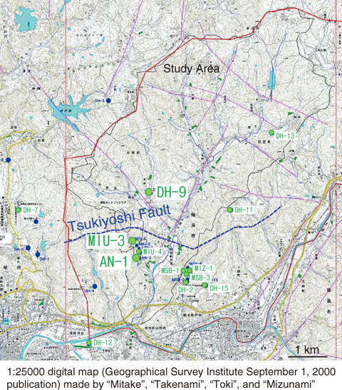
Fig.8-10 Locations of the study area and monitoring boreholes
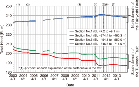
Fig.8-11 Example of groundwater-pressure change by an Earthquake (MIU-3 borehole)
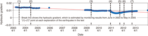
Fig.8-12 Example of hydraulic-gradient change by an earthquake (between the DH-9 and MIU-3 Boreholes)
For geological disposal for high-level radioactive waste, evaluating the groundwater-flow condition is important. Therefore, evaluating the groundwater-pressure change is necessary because this distribution and its change help to control groundwater flow. Long-term groundwater-pressure monitoring has been conducted in our field of study (Fig.8-10), and it was found that groundwater-pressure changes as a result of earthquakes. The earthquakes that changed pressure include (1) the Tokachi-oki earthquake of 2003, (2) the earthquake off the coast of Kii Peninsula in 2004, (3) the Suruga Bay earthquake in 2009, (4) the 2011 earthquake off the Pacific coast of Tohoku, (5) the earthquake in the east of Mino in 2011, (6) the earthquake on the west coast of northern Sumatra in 2012, and (7) the earthquake off the Sanriku coast in 2012. Groundwater-pressure changes after each earthquake differed in each monitoring section. However, the changes all occurred in the same direction (increase or decrease) over the same monitoring section (Fig.8-11).
The change in hydraulic gradient differs depending on the magnitude or the distance between the epicenter and the monitoring point for each earthquake (Fig.8-12). Therefore, we will continue long-term groundwater-pressure monitoring to confirm changes in the hydraulic gradient.
These results show that it is important to focus on not only the change in groundwater pressure but also that in the hydraulic gradient in evaluating the long-term stability of the groundwater-flow condition.

