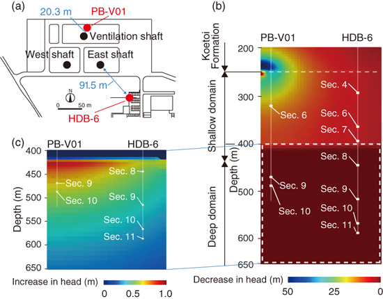
Fig.8-20 Location of shafts and boreholes, and vertical distribution of disturbance of the hydraulic head a year after drainage by hydromechanical coupled simulation
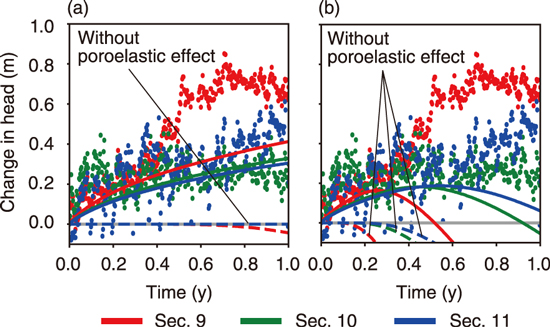
Fig.8-21 Comparison of the simulated and observed disturbances of the hydraulic head at monitoring sections deeper than 500 m in HDB-6 borehole
Estimation of the low-permeability domain in the subsurface is important for the safety assessment of geological disposal because solute transportation is restrained by the low seepage of groundwater there. Drainage during the excavation of shafts has a large impact on the groundwater flow, and the hydraulic head responds to the drainage even in the low-permeability domain where only small hydraulic responses were usually obtained by conventional hydraulic tests. In this study, for evaluating the effective hydraulic conductivity in the Wakkanai Formation located in the subsurface at depths beyond 250 m, we simulated the hydraulic head in the monitoring boreholes after the depth of the ventilation shafts of the Horonobe Underground Research Laboratory (URL) reached 250 m (Fig.8-20(a)).
The subsurface around the Horonobe URL consists of soft sedimentary rocks. These soft rocks deform depending on the drainage of the contained groundwater, and this deformation, in turn, affects the hydraulic responses. We simulated the change in the hydraulic head during the excavation considering the coupled hydromechanical effect (i.e., the poroelastic effect).
A referential simulation model was constructed based on the geological information of the Koetoi and Wakkanai formations in the boreholes near the URL. The Wakkanai Formation was further divided into two domains of shallow and deep domains at a depth of 400 m according to the mechanical stress conditions. The hydraulic conductivity values measured in in situ experiments were assigned to the Koetoi Formation and the shallow domain of the Wakkanai Formation. The hydraulic conductivity low as intact rock was assumed in the deep domain of the Wakkanai Formation. Fig.8-20(b) shows the simulation results of the disturbance of the hydraulic head in the vertical direction one year after drainage. The hydraulic head in the Koetoi Formation and shallow domain of the Wakkanai Formation decreased depending on the drainage from the ventilation shaft. The hydraulic head in the deep domain of the Wakkanai Formation increased because of the poroelastic effect and was maintained high because of the low hydraulic conductivity (Fig.8-20(c)). Fig.8-21 compare the observed and simulated changes in hydraulic head at the monitoring sections deeper than 500 m. Fig.8-21(a) shows the results of the referential model with high and low hydraulic conductivity values in the Wakkanai Formation, and Fig.8-21(b) shows the model results obtained considering high hydraulic conductivity in both shallow and deep domains. Both results reproduce the increase in the hydraulic head by considering the poroelastic effect. However, the results of the referential model shown in Fig.8-21(a) are more consistent with the observed results than those shown Fig.8-21(b), and the hydraulic conductivity in the deep domain of the Wakkanai Formation can be estimated as corresponding to low permeability considering the intact rock. In addition, comparisons of our other simulation results from models with different hydraulic conductivity values indicate that the hydraulic conductivity decreases with depth in the Wakkanai Formation.
This result can be interpreted as indicative of a decrease in the fault hydraulic connectivity with depth in the Wakkanai Formation because the fault hydraulic connectivity mainly dominates the hydraulic conductivity around the Horonobe URL.
(Yusuke Ozaki)

