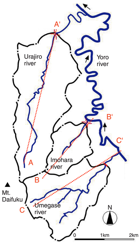
Fig.5-18 Map of position of 3 rivers (Urajiro, Imohara and Umegase River)
Fig.5-19 A conceptual representation of a three-dimensional groundwater flow in a research area
In the safety assessment for geological disposal of long-lived radioactive waste, it is important to estimate radionuclide migration to human environments through groundwater flow. We are studying regional groundwater flow systems.
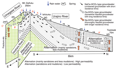
In order to understand a regional groundwater flow system on a 10-100km scale, it is necessary to validate a conceptual representation of flow system from the recharged area to discharged area comparing with the observed data. Therefore, we investigated a sedimentary rock area in the Yoro river basin (Fig.5-18) and constructed a conceptual flow model of the region using the observed data of flow rate, chemical composition of groundwater, and isotopic ratios of hydrogen and oxygen in water samples collected from wells, rivers and springs.
From the observed flow rates, analyzed results of water samples and Mt. Daifuku's spatial characteristics, it is found that the groundwater recharged at Mt. Daifuku flows toward the east-northeast which is the direction in which the sandstone and high permeability mudstone strata run, and is discharged in the Imohara river and the Umegase rivers. In addition, it is estimated that a part of groundwater flows down deeper than 100m where the stratum tilts, and then flows out to the surface layer basin through fractures in a sandy-mudstone stratum with low permeability (Fig.5-19).
Chemical composition and isotopic data indicated that most of the groundwater is precipitation recharged at Mt. Daifuku, and that the groundwater is of the NaCa-HCO3 type which is chemically unreacted groundwater with short residence time or of the Ca-HCO3 type which is reacted groundwater with long residence time. The groundwater discharged into the downstream of the Urajiro river and the Umegase river was found to include the Na-HCO3 type groundwater which has been reacted to a great extent, and which rose from a deep stratum.
Considering the above results, we conclude that a hydrological approach (measuring the flow rate of river and estimating underground flow) combined with a geo-chemical approach (analyzing the groundwater composition including isotopic ratios) is a useful method for evaluating the relationship between surface water, shallow groundwater and deep-seated groundwater which needs to be determined in order to establish a regional groundwater flow model.
The present study was conducted in FY2006 as part of the "Study of Influence of Hydrologic/Geological Changes Related to Geological Disposal" commissioned by the Nuclear and Industrial Safety Agency (NISA) of the Ministry of Economy, Trade, and Industry (METI).