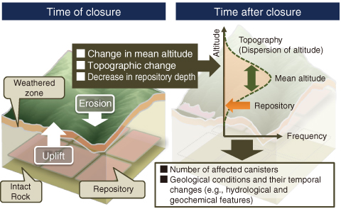
Fig.8-29 Conceptual uplift erosion model for repository and evolution of topography over time
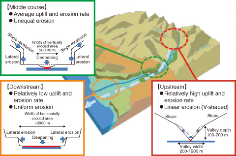
Fig.8-30 Conceptual erosion model
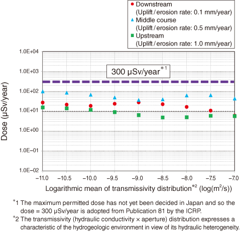
Fig.8-31 Results of safety assessment assuming that repository reaches ground surface by uplift and erosion
Japan is tectonically active, so a site for the geological disposal of high-level radioactive waste (HLW) must be demonstrated to be stable over the long term. Areas identified by geological investigation that are more likely to experience catastrophic natural events should be avoided (e.g., areas with major fault movements or volcanic activity). More widespread phenomena identified on regional and global scales, however, are more difficult to avoid (e.g., uplift or erosion and changes in sea level). For uplift and erosion, the distance between a 300-m-deep repository and the biosphere can be reduced, and in the worst case, the repository could become exposed at the ground surface. The present study provides a method to evaluate the effects of uplift and erosion on the safety of the geological disposal of HLW.
In previous safety assessments, the rate of erosion was assumed equal to the rate of uplift, so the repository would approach the ground surface at a constant velocity. After reaching the ground surface, the repository was then assumed to erode uniformly. In reality, there are many areas with different rates of uplift and erosion. A systematic method to identify and express the parameters for safety assessments has been developed by using more realistic rates of uplift and erosion (Fig.8-29).
Fluvial erosion is the main erosion process in Japan; so to evaluate the subaerial exposure of a repository, the present study models erosion depending on the precise locations along a river’s course (Fig.8-30). The effect on human health is evaluated based on the assumption that radionuclides are released in the biosphere by erosion. In all cases considered, the dose rates are below the target value suggested by the International Commission on Radiation Protection (ICRP) (Fig.8-31). These results can be explained by the low amount of erosion because of the localized upstream deepening, the longer downstream decay time due to the slow rate of uplift and erosion, even considering the large amount of erosion due to uniform deepening, and the average of these two conditions in the middle course.

