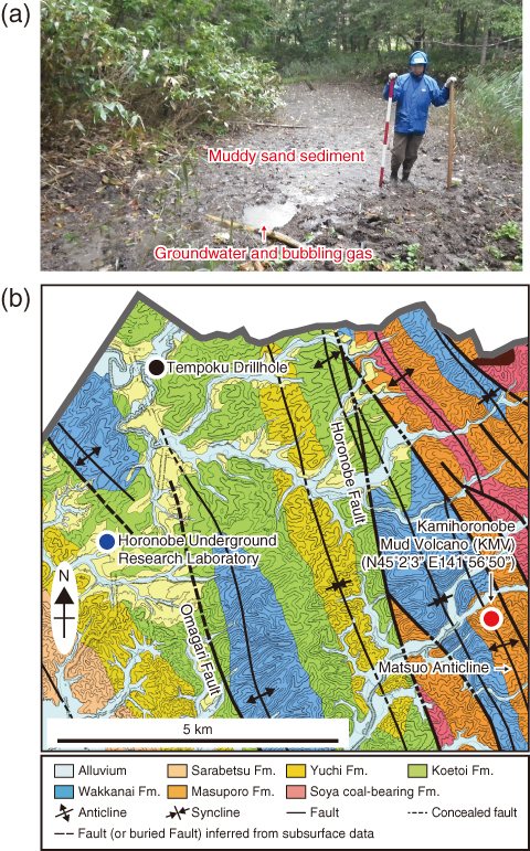
Fig.8-14 (a) Photograph of vent from which muddy sand and gas was sampled. (b) Geological map of the area of KMV
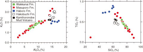
Fig.8-15 Bivariate plots of K2O-Al2O3 and SiO2-TiO2 relationships for muddy sand and core samples from the area of Fig.8-14
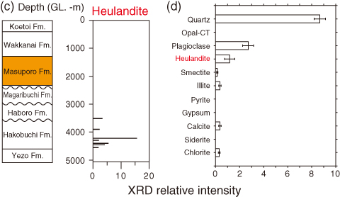
Fig.8-16 Abundances of minerals as a function of depth: (c) heulandite from a report on Tempoku Drilling (JNOC, 1995) and (d) data from the present study
Recently, applied earth science research into onshore mud volcanism has focused the safety of underground facilities, disaster mitigation, and the greenhouse effect on the climate. A topographical heightening created by a mud irruption along with high-pressurized groundwater and/or gas is called a mud volcano (MV), and the genetic process of creating a MV is called mud volcanism or the MV phenomenon.
Our R&D program must assess the geosphere stability to isolate radioactive waste over the long term. The goals of this R&D activity may be summarized in the following sequential steps: (1) determine the relationship between anomalously high formation pressure and mud volcanism, (2) narrow the range of geological settings where MV can occur in the future, and (3) clarify the impact of MV to the waste disposal system. Because only two onshore MVs are known in Japan (i.e., the Niikappu MV in Hokkaido and the Matsudai MV in Niigata), information from the case studies of other onshore MVs is needed to completely characterize onshore MVs. In this study, we investigated the origin of muddy sand sediments from the Kamihoronobe MV (KMV) located in Hokkaido (Fig.8-14).
Fig.8-15 compares the SiO2, TiO2, K2O, and Al2O3 contents of KMV samples with those of core samples from each formation in this area, as described in the Tempoku Drilling (TD) (JNOC, 1995; Fig.8-14(b)). Fig.8-15 suggests that the chemical compositions of the KMV samples indicate a mix of materials from the Masuporo, Haboro, and Hakobuchi formations. By analyzing with X-ray diffraction (XRD), we compared the mineral composition of muddy sand samples with that of core samples (see published TD report) (Fig.8-16). Fig.8-16(c) shows that stratigraphically, heulandite, which is a type of clay mineral, is detected only in the Hakobuchi Formation, and Fig.8-16(d) shows that heulandite occurs in the muddy sand sediments. Considering that the Masuporo Formation is the youngest sedimentary formation below the KMV, the depth of the Hakobuchi Formation was estimated from the thickness of the formation to be 2200–2400 m (Fig.8-16(c)). Based on this evidence, we concluded that muddy sand from the KMV migrated from depths of over 2200–2400 m and was incorporated in the rock fragments from overlying formations.
Although we concluded that the materials came from great depths, we still need to study how MVs are generated and their lifetime or cycle time.

