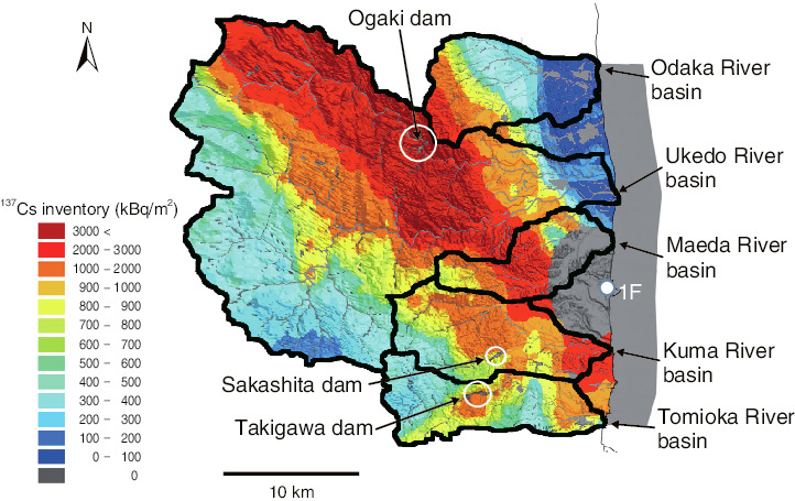
Fig.1-35 A spatial distribution of the 137Cs inventory between five river basins (Odaka River, Ukedo River, Maeda River, Kuma River, and Tomioka River) near the 1F (data from the Second Airborne Monitoring Survey, May 2011)
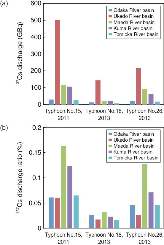
Fig.1-36 Amount of 137Cs discharge (a) and discharge ratio (b) from five river basins under heavy-rainfall events such as typhoons
A large amount of radiocesium derived from the TEPCO’s Fukushima Daiichi NPS (1F) accident remains in the top surface-soil layer due to strong absorption to soil particles including clay minerals. Therefore, some radiocesium is discharged into rivers and oceans through rainfall events such as typhoons due to water flow and sediment transport. By understanding the characteristics of radiocesium discharge, it is possible to predict the amount of this discharge in the future.
In this study, we extended an existing watershed model of water flow and sediment transport to calculate the migration of cesium-137 (137Cs) into the environment. We simulated water, sediment, and 137Cs discharge during heavy-rainfall events such as typhoons in five contaminated river basins near to 1F (Fig.1-35).
In the simulation, the amount of 137Cs discharge and the 137Cs-discharge ratio (fraction of the amount of discharge against the initial fallout) are calculated in each river basin. The quantities for each basin are considered to differ due to the amount of sediment supplied to the river by precipitation, the initial 137Cs inventory, the presence of a dam reservoir, and the land use.
Our results appear in Fig.1-36. The Ukedo River basin has a large amount of 137Cs discharge due to a high initial 137Cs inventory; however, its discharge ratio was low. The dam reservoir, which served to trap sediment discharge from the upper part of the river, may reduce discharge of radiocesium attached to the suspended sediment downstream. In addition, forested areas can reduce the amount of sediment discharge because surface-water flow does not occur much. Therefore, the Ukedo River basin had low 137Cs discharge because the area upstream of the dam reservoir was forested. The Maeda River basin have no dam reservoir and a highly 137Cs-contaminated paddy-field area, which supplied significant quantities of sediment discharge, thus resulting in a high 137Cs-discharge ratio.
Verification and improvement of this study can be used to predict the amounts of sediment and 137Cs discharge from basins in future.

