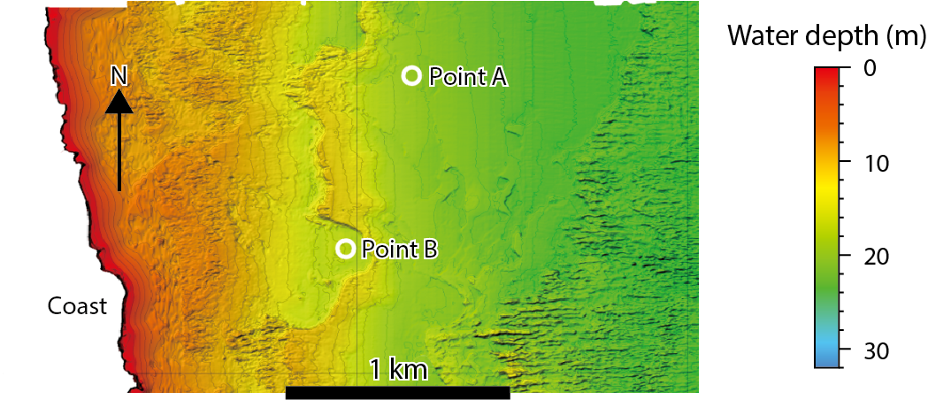
Fig.1-32 Bathymetric map and sample locations

Fig.1-33 Vertical distribution of 137Cs activities (kBq m-2 cm-1), total inventory per unit (kBq m-2), and median grain size (D50) of samples collected via core-sampling method
The accident at the TEPCO’s Fukushima Daiichi NPS that occurred following the Great East Japan Earthquake and the resulting tsunami in March 2011 resulted in extensive release of radioactive cesium into the Pacific Ocean. Understanding the features of 137Cs transport from contaminated mountain forests to coastal sinks is key to the revitalization of marine industries. The 137Cs distribution in shallow seas, which are major settlement areas for particle-sorbed 137Cs, is very important when studying 137Cs transport from contaminated mountain forests to coastal sinks. Therefore, we examine the heterogeneity of the 137Cs distribution in seabed sediments at sea depths <30 m. A bathymetric survey and sonic prospecting were conducted to map the occurrences of seabed sediments, and core sampling of such sediments was performed to describe the vertical profile of the 137Cs distribution therein.
The bathymetric map shown in Fig.1-32 indicates that terrace-like seafloors consisting of gently descending slopes opposite to the coastal sides (dip side; around point A, Fig.1-32) and steeper ascending slopes on their coastal sides (up-dip side) extend in the investigation area. In particular, point B is located in a semicircular depression surrounded by steep sides. According to the results of sonic prospecting, the surface ratio of bedrocks (Pliocene sedimentary rocks) is 52 %, suggesting that the 137Cs distribution on the seafloor is less than half of that in the investigation area. Seabed sediments tend to accumulate at the base of the steeper ascending slopes. Fine-to-medium sand is the main constituent of the seabed sediments (Fig.1-33(a)) and the distribution of the finer fraction (silt) is limited to a quite narrow zone of semicircular depression (point B).
The 137Cs-inventory values collected at point B are greater than those at point A, and the grain sizes (D50 values) at point B are homogeneously silt (Fig.1-33). The current velocities of the bottom layer at point B, which were observed using current profilers towed by ships, were lower than those at point A. These results suggest that the steep slope around the semicircular depression area appears to play a major role as a topographic barrier in reducing the current velocity, prompting the settlement of fine-grained particles. In other words, the features of the seafloor topography are determined to be significant factors controlling the horizontal and vertical distributions of 137Cs in the seabed sediments. Areas with similar seafloor topographies of the semicircular depression were not identified in the investigation area, suggesting that distributions with remarkably large 137Cs inventories (more than several thousands of kBq m-2) are strictly limited.
Our research also revealed the continuous 137Cs distribution at depths greater than 81 cm (Fig.1-33(b)). Vertical 137Cs profiles in seabed sediments obtained in previous studies have been insufficient to evaluate 137Cs concentrations because information about the distribution of 137Cs at the lowermost depths of these sediments is lacking, owing to short core-sampler lengths (almost less than 20 cm).
Therefore, these results indicate that estimation of the 137Cs inventory in shallow seas should be performed carefully, considering the extent of the 137Cs distribution along the vertical depth and the surface ratio of the seabed sediments.