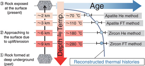
Fig.8-22 Reconstructing the time-temperature history involving uplift and cooling of a rock sample based on multi-thermochronometers

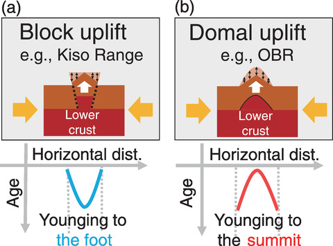
Fig.8-23 Comparing uplift mechanisms and the spatial age distributions between two mountains
Sites selected for geologic disposal of high-level radioactive waste (HLW) should be stable in the long term (i.e., 105 yr). At the Tono Geoscience Center (TGC), techniques for evaluating and investigating the long-term geosphere stability have been developed. In particular, estimating the uplift/erosion mechanisms plays a key role in evaluating risks of HLW approaching biospheres and simulating groundwater flow conditions related to topographic evolution, thereby contributing to the design and safety assessment of a disposal facility.
Thermochronology, a branch of radiometric dating, is a useful method to evaluate the temperature of a rock sample changing over time (i.e., the cooling history). Radiometric dating employs radioactive decay, in which radionuclides (e.g., uranium) naturally decompose into other nuclides at certain rates. At TGC, fission-track (FT) and (U-Th)/He (He) thermochronometers are available. These instruments can be used to determine the age of a sample by analyzing the chemical composition or crystal structure subject to micro-scale (<0.1 mm) minerals, such as apatite and zircon. Closure temperatures, below which dating methods begin to record their ages, have been determined theoretically and experimentally. The obtained age indicates when the sample was cooled to its closure temperature. Thus, an uplift/erosion history of rock can be represented by a cooling history from the hot to the cold domain (i.e., deep underground to the surface), as shown in Fig.8-22. Young ages indicate short transfer durations, implying that the rock was recently located in a warmer (i.e., deeper) location. By assuming thermal gradients, uplift/erosional histories (i.e., how quickly the rock was moved to the surface) can be reconstructed. Furthermore, a large sampling of ages across a mountain can provide a macro-scale (i.e., a few to a dozen km) uplift/erosion pattern over the entire mountain.
The Tohoku district has been affected by the E-W compression for three million years due to the subduction of the Pacific Plate at the Japan Trench, which triggered the 2011 off the Pacific coast of Tohoku Earthquake. This compression has also caused the uplift of the Ou Backbone Range (OBR) along the central axis of Tohoku; however, the mechanism of uplift has not yet been clarified. Therefore, we obtained FT and He thermochronometric data at densities higher than previous studies. Our results suggested a domal uplift model of the OBR, which differs from other Japanese mountain ranges, such as the Kiso Range, as summarized in Fig.8-23. The Kiso Range is mainly uplifted by reverse faults at the foot, whereas the OBR is uplifted by the hot zone underneath it. We will continue to investigate whether such domal uplift commonly occurs in other subduction zones in Japan and overseas.
This study was supported by the Japan Society for the Promotion of Science (JSPS) KAKENHI Grand-in-Aid for Scientific Research on Innovative Areas, “Resolution of crustal deformation of the Japan Islands in various spatio-temporal scales” (No.JP26109003).
(Shoma Fukuda, Shigeru Sueoka)