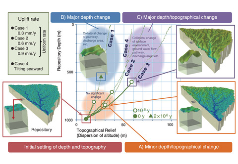
Fig.8-26 Example of topographical and repository depth change calculated using the developed tool
Sites for geological disposal of high-level radioactive waste (HLW) are selected based on exclusion requirements to avoid significant effects from natural phenomena, such as volcanic/igneous activity, uplift/erosion, and earthquake/fault activity. On the other hand, the potential effects of climate change and slow uplift/erosion affecting wide areas should also be studied.
Therefore, we developed a method to assess the temporal changes in topography and depth of a disposal facility due to uplift/erosion to make it possible to evaluate the effects of uplift/erosion on the performance of geological disposal systems, including location-dependent effects. The developed tool can quickly calculate topographical and repository depth change by changing the conditions such as the topography, uplift rate and distribution, and location of the disposal site. Changes in the topography and repository depth caused by uplift/erosion likely influence the nuclide migration behavior, including the pathway from the disposal to the surface and the discharge area. On the other hand, these changes depend on the initial conditions, such as the initial topography, disposal site location, and uplift rate. Three patterns of topographical and depth changes were identified based on the result depending on the initial conditions.
A) minor changes in topography and repository depth,
B) major changes in repository depth, and
C) major changes in topography and repository depth.
The calculated repository depth and topographical changes assuming multiple uplift rate settings (i.e., Cases 1-4) using the tool are summarized in Fig.8-26. By applying this tool to various conditions, calculating the temporal changes in topography and repository depth, and estimating which pattern they follow, the impact of uplift and erosion on safety assessment can be estimated. The developed tool can also be used to estimate which conditions should be focused on the safety assessment when considering the influence (e.g., changes in the migration pathway changes or the discharge area to the surface). Additionally, the quantitative information on topographical and depth changes provided by this tool can be used to evaluate groundwater flow or nuclide migration pathways to the surface.
Overall, the developed tool improves nuclide migration analyses and biosphere assessments.
(Masaaki Yamaguchi)

