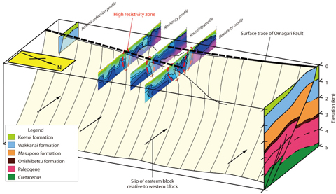
Fig.2-18 Inferred 3-D distribution of the Omagari Fault
Distributions of permeable zones in rocks influence the performance of far field barriers for the geological disposal of radioactive wastes. A fault zone composed of plural faults is a typical geologic permeable zone. For the geological disposal performance assessment, investigating distributions of the fault zone is important.
Investigation methods include geological mapping, remote sensing, airborne survey, geophysical prospecting and borehole investigation, and the best combination of methods depends on geological and social conditions.
In this study, heretofore unknown distribution and hydrogeological properties of the Omagari Fault were investigated by geological mapping, reflection seismic survey, audio-frequency magnetotelluric survey, and borehole investigations. The results showed that magnetotelluric survey in particular is effective for mapping the 3-D distribution and hydrogeological properties of a fault zone in massive rocks where both saline and fresh water exist. Uplifted marine sediments tend to exhibit distinctive resistivity due to the difference of chlorinity of formation water caused by the mixing of saline water with fresh water after uplift. Thus, distributions of fresh water zones can be searched by investigation of resistivities of the sediments. In addition, these distributions in massive rocks are largely caused by geological structures such as fault zones and their hydrogeological properties. Therefore resistivities in uplifted and massive marine sediments likely reflect the distribution and hydrogeological properties, as shown by this study.