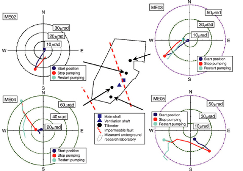
Fig.2-16 Measurement result of tiltmeter
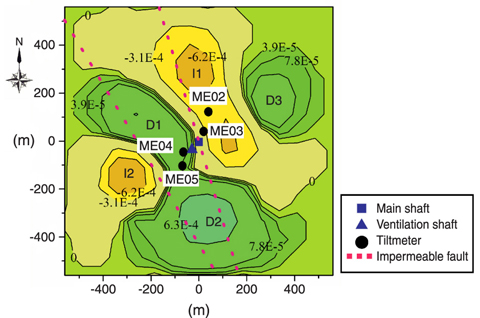
Fig.2-17 Result of inverse analysis
In R&D on geological disposal technology of high-level radioactive waste (HLW) and construction of large-scale structures underground which protects the environment, it is important to evaluate groundwater flow deep underground.
To evaluate the groundwater flow, it is necessary to study the distribution of hydraulic conductivity, pore pressure and hydrogeological structures which control the groundwater flow. Generally, these data can be obtained by borehole investigation. However, investigations and observations using many boreholes require too much cost and time, and it is important to develop a simple method to complement the borehole investigation data.
We developed a simple method to characterize the hydrogeological structures by measuring the minute tilt movement of the ground surface in collaborative research with Tohoku University.
In this research, we developed and modified the method for estimating a deep groundwater volume change by an inverse analysis of tilt change caused by the groundwater flow measured by borehole testing and inflow to a large-scale structure. To test the applicability of this method, we performed an inverse analysis using a tilt data obtained from in situ measurement to estimate the hydrogeological structures.
In the Mizunami Underground Research Laboratory, tilt data measured by four tiltmeters with a resolution of 10-9 radians was used. This measurement data shows that the tilt change is caused by the groundwater flow change accompanying shaft excavation (Fig.2-16).
From the result of estimation of a groundwater volume change at the depth of ground level -160m by an inverse analysis using the tilt data during shaft excavation, it was estimated that the groundwater volume decreasing area extended to the north-northwest and to the south-southeast of the shafts (Fig.2-17).
The result indicates that the decrease in groundwater volume occurred mainly in the area surrounded by two impermeable (low permeability in the normal direction to the fault plane) faults which were already characterized and studied in previous research work. Therefore this decrease of groundwater volume is caused by inflow to the shafts supplied by the groundwater from this restricted area. This result is consistent with previous research, and thus the method we developed is a one effective way to estimate the hydrogeological structures.