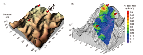
Fig.1-30 (a) A topographical map with a bird’s-eye view and (b) a three-dimensional contour map of the air-dose rate of the forest catchment
Most of the area contaminated by the radioactive cesium (Cs) released by the TEPCO’s Fukushima Daiichi NPS (1F) accident is mountainous and forested. This region had a prosperous forestry industry; thus, estimating the dose-exposure to forest workers and the contamination of forest products is critical. To do this, the spatial distribution of radioactive Cs deposition in the forest must be measured in detail; however, most mountainous areas are difficult to access for direct measurement. Although airborne monitoring has been conducted in this region, its capabilities in such complex topography remain unverified. Therefore, data must be collected to verify airborne monitoring.
We conducted air-dose-rate measurements in a mountainous catchment subject to radioactive Cs deposition from 1F (Fig.1-30(a)) to verify airborne monitoring and understand the spatial variation of radioactive Cs deposition in a mountainous forest with complex topography. To achieve this, we used KURAMA-II, a GPS-aided mobile radiation-monitoring system developed by the Kyoto University Research Reactor Institute. To perform systematic measurements, a researcher carried the KURAMA-II unit on a backpack frame while walking through the area. Using the collected data, we conducted a geostatistical analysis and generated a contour map, which revealed the effects of topography upon the spatial distribution of radioactive Cs (Fig.1-30(b)).
The results showed that the air-dose rates in the mountainous forest are highly variable spatially and topographically anisotropic. The air-dose rates increased with elevation, indicating that more radioactive Cs was deposited on ridges. The results suggest that it is important to consider topography when selecting sampling points and resolution to assess the spatial variation of dose rates. The results of the comparison with airborne monitoring imply that such monitoring provides an accurate estimation of air-dose rate averaged over thousands of meters, even in mountainous areas.

