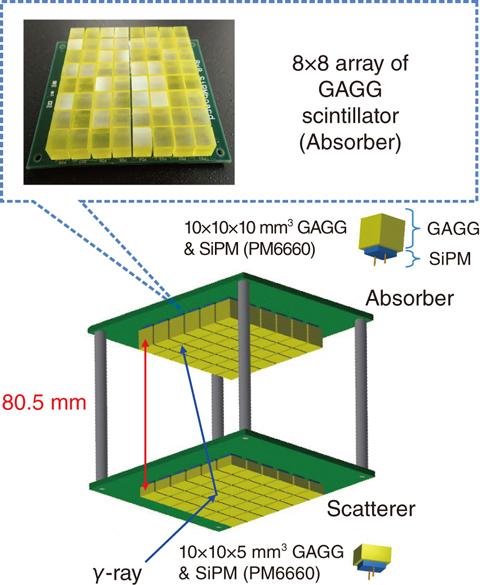
Fig.1-21 New Compton camera using GAGG scintillators

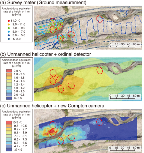
Fig.1-22 Ambient dose-equivalent-rate map
To accurately ascertain the situation of the wide area contaminated by the radioactive cesium (Cs) emitted following the accident at the TEPCO’s Fukushima Daiichi NPS and to conduct efficient decontamination work, it is effective to use an unmanned helicopter to rapidly survey a wide area from the sky. However, difficulties were encountered in mounting an ordinal detector with a single scintillator in that its resolution was only approximately 80 m owing to its sensitivity to radiation from all directions.
Therefore, building upon the prototype Compton camera that was mountable on an unmanned helicopter and could measure the incidence direction of γ-rays, a new Compton camera (Fig.1-21) was developed here. This camera had four times as many detector elements as the prototype, with each comprising a Ce:Gd3(Al,Ga)5O12 (GAGG) scintillator and a silicone photomultiplier. The resulting increase in the area of the cross-section owing to increase in the number of detector elements for each layer improved the sensitivity 5-fold. This enabled analysis to be conducted with sufficient statistical precision even after strict event selection for high positional resolution. Expansion of the interlayer distance made the solid angle of the 2nd layer’s scintillator viewed from the 1st layer’s one smaller than that of the prototype. This improved the angular resolution from 14° to 10°.
In February 2015, we performed programming and hovering flights over the Ukedo riverbed in Namie, Fukushima Prefecture, during which the unmanned helicopter flew along a pre-planned comb-shaped path (50 min) and then hovered in various positions (15–20 min for each position), respectively. In the measurement, the helicopter position and measured γ-ray-event data were recorded. In the analysis, the Compton scattering angle was restricted to a small value by selecting the events with a small scattering energy, and under this condition, γ-ray events originating below the detector were selected. For the programming flight, the count-rate data obtained were converted into the ambient dose-equivalent rate. Based on the dose rate with position data, a map was produced by the interpolation method with the geographical information-system software. For the hovering flight, after selecting events whose summed scatterer and absorber energies were near the 137Cs peak energy of 662 keV, a γ-ray image was obtained using the reconstruction software for the γ-ray-intensity distribution.
Fig.1-22(c) is the ambient dose-equivalent-rate map at a height of 1 m, as obtained from the programming flight. From this map, we confirmed that relatively small hot spots could be detected. Thus, rapid measurement of the ambient dose-equivalent-rate distribution over a wide area with a position resolution of about 10 m was realized using the new Compton camera.
The present study was sponsored by the Japan Science and Technology Agency (JST).