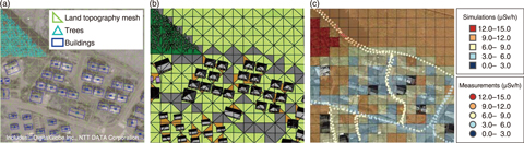
Fig.1-39 Process of modeling air dose rates with 3D-ADRES
To minimize the external radiation exposure of residents returning to areas where evacuation orders are being lifted after the accident at TEPCO’s Fukushima Daiichi NPS (1F) eight years ago, the distribution of air dose rates in inhabited areas must be understood.
Predicting the distribution of air dose rates requires detailed calculations that reflect the differences between the amounts of radioactive cesium (134Cs and 137Cs) on roads and uncovered surfaces, and the effects of shielding by buildings, trees, and land topography. Previous researchers have made simplifying assumptions, such as assuming completely flat land or ignoring the shielding effect of buildings and trees. To this end, JAEA’s Center for Computational Science & e-Systems has worked in collaboration with the Fukushima Environmental Safety Center to develop the 3D-ADRES (3D Air Dose Rate Evaluation System) calculation system. This system was designed to create detailed 3D models of residential areas in Fukushima Prefecture to improve the precision of calculations of air dose rate distributions.
In 3D-ADRES, models are created for a target area by first displaying a satellite image or aerial photograph of the location (Fig.1-39(a)). Digital Elevation Model (DEM) geospatial data are used to create a 3D model of the land surface topography by using a triangular mesh (Fig.1-39(a)). Buildings and trees are added on top of the land topography model with heights determined by the Digital Surface Model (DSM) data, thus creating a realistic model of the target area (Fig.1-39(b)). The model is then converted into a format suitable for the PHITS code developed by JAEA (Fig.1-39(b)). PHITS uses the Monte Carlo method to simulate the paths taken by gamma rays emitted by radioactive cesium. It models the scattering and changes of direction of gamma rays due to interactions in air, as well as absorption by buildings and trees. In this way, it becomes possible to reproduce the complicated air dose rate distribution around buildings and houses (Fig.1-39(c)). Undertaking radiation transport simulations with PHITS allows for air dose rate distributions for the past, present, and future to be calculated.
3D-ADRES and PHITS were used to calculate the air dose rate distribution in an area near the 1F and to examine the effects of buildings, trees, and asphalt on this distribution. The results indicated that wind and rain easily washes radioactive cesium off of buildings and asphalt roads, thus causing air dose rates approximately 60% lower than expected. This effect was greater than the dose rate reduction that occurs due to the shielding of gamma rays by buildings and trees.
Future work will involve using 3D-ADRES and PHITS to evaluate air dose rates inside rooms in houses and buildings where residents tend to spend long periods of time. The developed model will contribute to minimizing residents’ external radiation exposures and predicting the reduction in air dose rates in residential areas over time. Furthermore, modern technologies such as 3D laser scanners and GPS-equipped cameras will be implemented to improve the detail of the models whilst developing automation techniques to streamline model creation.

