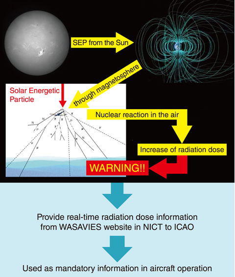
Fig.4-11 Information flow in WASAVIES
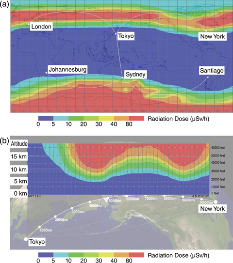
Fig.4-12 Example of radiation doses calculated by WASAVIES
When a large solar flare occurs, the radiation doses due to solar energetic particle (SEP) may increase, especially at flight altitudes, and can thus be a potential hazard to aircrews and passengers. Therefore, the development of a system for nowcasting and/or forecasting radiation doses due to SEP exposure is an important challenge in space weather research. Collaboration with other research fields such as nuclear physics and radiological protection is key for such a development.
A physics-based model was thus developed for SEP dose estimation anywhere in the atmosphere; this model, designated as the Warning System for Aviation Exposure to Solar Energetic Particles (WASAVIES) and summarized in Fig.4-11, was developed via collaboration between several institutes in Japan. WASAVIES is based on the combination of three SEP transport simulation models from the Sun to the ground level of the Earth. When the calculated radiation doses at flight altitude exceed a certain threshold, a warning is issued to airline companies through the International Civil Aviation Organization (ICAO). JAEA was responsible for developing the SEP transport simulation model in the atmosphere based on PHITS and integrating the models to develop the automatic analysis program.
The performance of WASAVIES was examined by analyzing the four major solar particle events of the 21st century; the accuracy of the nowcast data obtained by the model has been validated by the reproducibility of ground and satellite observations. The WASAVIES-calculated worldwide dose rate map at 12 km and route-dose rate map between Tokyo and New York during the peak of the solar particle event occurring on Jan. 20th, 2005 are shown in Figs.4-12(a) and (b) respectively. The complicated latitude, longitude, and altitude dependences of the dose rates, such as the southern asymmetry, can be seen in these figures, owing to the sophisticated physics models implemented in WASAVIES.
A web-interface of WASAVIES was also developed and opened via the public server of the National Institute of Information and Communications Technology (NICT, https://wasavies.nict.go.jp/) on Nov. 7th, 2019. The radiation dose during solar flares calculated via WASAVIES will be used as mandatory information for aviation operation management by ICAO. This study demonstrates a successful example of interdisciplinary research achieved through collaboration among researchers in various fields, such as space weather, solar physics, upper atmosphere, nuclear physics, and radiation protection.
This study was partly supported by the Japan Society for the Promotion of Science (JSPS) KAKENHI Grant-in-Aid for Scientific Research on Innovative Areas (Research in a proposed research area)(No.15H05813).
(Tatsuhiko Sato)

