
Fig.1-23 Aerial radiation monitoring using an unmanned helicopter
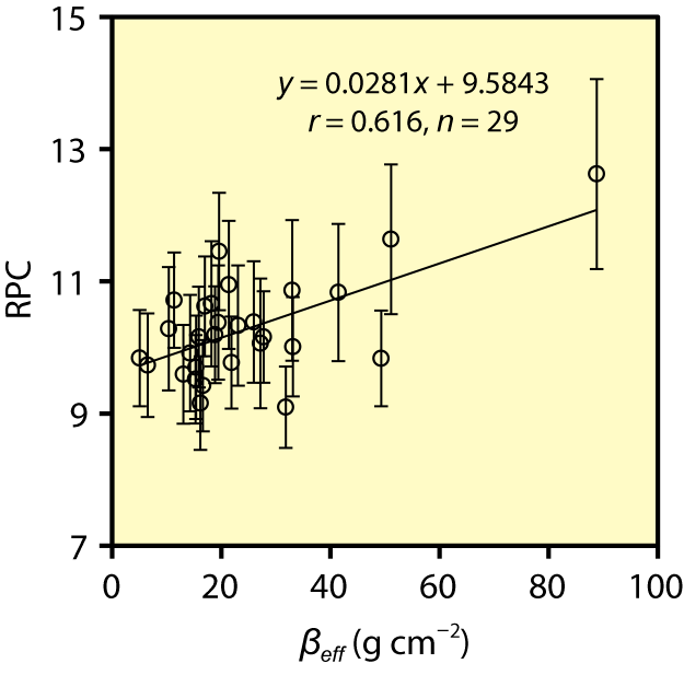
Fig.1-24 Relationship between the result of aerial radiation monitoring and the collection of core soil
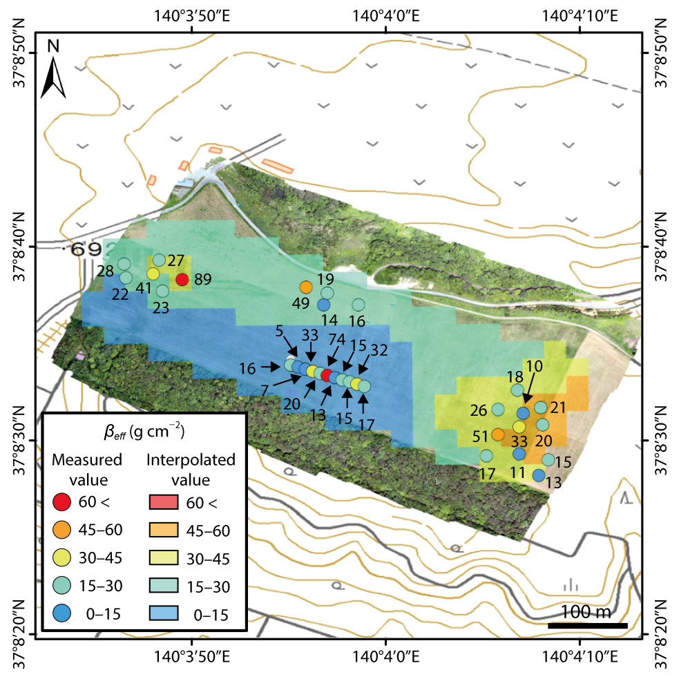
Fig.1-25 Comparison between the estimated value of βeff and actual βeff
Seven years have passed since the accident at the TEPCO’s Fukushima Daiichi NPS (1F). It has been reported that radiocesium deposited by the accident was transferred into deeper soil with rainfall, inversion tillage (a type of decontamination work) and disturbance by wild animals. It is necessary to readily detect radiocesium depth in the soil from the ground surface. This method would be helpful for determining the depth of decontamination. We have developed an aerial-radiation-monitoring method using an unmanned helicopter (R-Max G1, YAMAHA Co., Ltd.), which is used to rapidly and easily investigate the spread status of radiocesium on a wide scale.
In the present study, we succeeded in developing a method for acquiring radiocesium soil depth based on the characteristics of the γ-ray spectrum obtained by aerial radiation monitoring. To validate the theory in Fig.1-23, the contribution ratio of scattered γ-rays to direct γ-rays is compared to the vertical distribution of radiocesium in core soil at the same point in the farmland (Fig.1-25). Inversion tillage was performed in the farmland, except in the southern area. The value of the ratio of peak to Compton-scatter peak heights (RPC) is calculated based on the ratio of the counting rate of scatted γ-rays (50–450 keV) to that of direct γ-rays (450–760 keV) for γ-rays obtained by aerial radiation monitoring. We used the LaBr3(Ce) detector that showed good energy resolution for 137Cs. The vertical distributions of radiocesium in the core samples (0–60 cm) were obtained by random soil sampling using a core sampler in farmland. The vertical distribution of radiocesium in soil was expressed as a parameter, effective relaxation mass depth (βeff). As βeff increased, radiocesium distributed more deeply into the soil.
As shown in Fig.1-24, good agreement was observed between the RPC and βeff. The map of estimated βeff in the entire field in Fig.1-25 was created based on the above-mentioned equation. The result of core soil sampling is shown as a black circle in the result for aerial radiation monitoring over all farmland. The vertical distribution of radiocesium from farmland on a wide scale was investigated by aerial radiation monitoring using an unmanned helicopter. This method would be helpful for performing decontamination in the difficult-to-return zone over a wide scale.
This research was supported by grants from the Project of the NARO Bio-oriented Technology Research Advancement Institution “the special scheme project on regional developing strategy”.

